We're pushing fishing
TECHNOLOGY
to its limit and it feels good
- Fishing -
We gave you something to
CHIRP
about!
GO DEEPER WITH MORE POWER THAN YOU THOUGHT POSSIBLE
You spoke. We listened. And now we delivered! NavNet TZtouch3 incorporates a powerful internal 1 kW TruEcho CHIRP™ Fish Finder. For many, this is the perfect Fish Finder, but some need more power. So, we proudly bring you Deep Impact (DI-FFAMP), a high-powered 2/3 kW amplifier that connects to the internal TruEcho CHIRP™ Fish Finder. But if that's not enough, Deep Impact allows you to connect a 5 kW or 10 kW transducer with the BT-5. Go big or go home!
* Connectable to TZT12F/16F/19F only
Create and record accurate maps of the seabed with
Shaded Relief Mapping
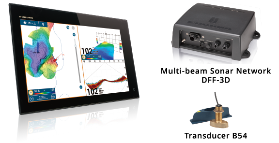
Powerful Multibeam Sonar for real-time detection of large areas of the seabed
Furuno's multibeam Sonar uses small transmitters and receivers and advanced signal processing technology to provide a real-time image of the seabed, covering an angle of 120° and a depth of up to 200m.
NavNet TZtouch3 (Ver. 2.01 or later) provides a seabed mapping function that efficiently creates high-definition seabed maps and displays them by color and isobaths.
VIDEO OF SEABED MAPPING IN PROGRESS
Tokyo Bay, [Playback Speed 10x]
Tokyo Bay, [Playback Speed 5x]
Yokohama Bayside Marina, [Playback Speed 5x]
Easily visualize the shape of the seabed with NavNet
This all-new feature uses the power of DFF-3D multi-beam sonar and the intuitive graphical representation of NavNet to provide a highly accurate and detailed high-definition view of the seabed and depth information around the vessel. With this powerful combo, you'll be able to find places that have never been referenced on fishing charts before!
* Azimuth Sensor Required
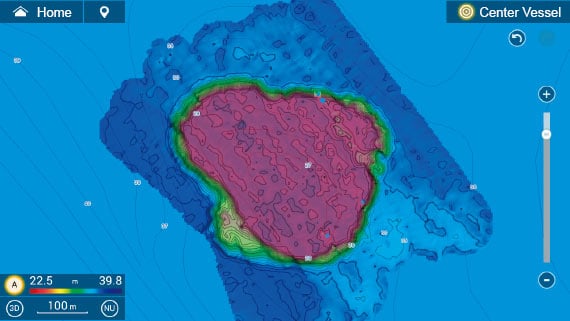
Seabed mapping image of the area around the third sea wall in Tokyo Bay
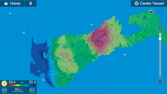
A fishing reef in front of Sarushima, an uninhabited island located in Tokyo Bay
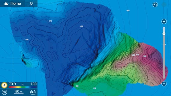
Mapping image of the middle of a strait in Tokyo Bay. The color-coded and detailed isobaths provide an intuitive understanding of the seabed conditions.
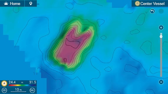
A wreck at a depth of 30m (off Kobe).
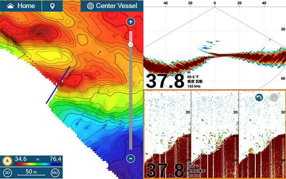
Image of the seabed off Akashi, near Kobe.
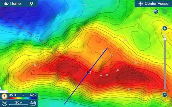
It is possible to map a wide area (blue bar) with high accuracy and efficiency.
Plenty of
FISHING
Technologies
Welcome to the future of high-powered, deep-dropping, full-featured Fish Finders. We’re not talking about your daddy’s Fish Finder. We took our commercial fishing know-how and put it into NavNet TZtouch3, giving you capabilities that a recreational line of Fish Finders has never seen. Reach unfathomable depths with Deep Impact!
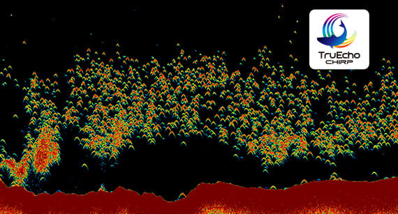
Find more fish with TruEcho CHIRP™
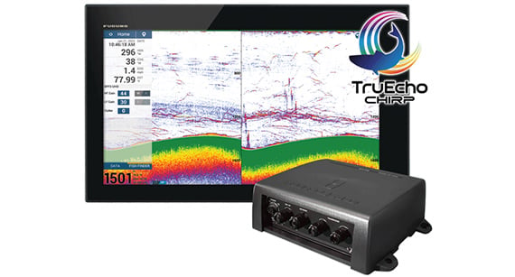
The internal 1 kW TruEcho CHIRP™ Fish Finder inside NavNet TZtouch3 is designed to operate across a wide range of frequencies utilizing a broadband transducer and delivers significant advantages to signal clarity & target definition. Due to the constant sweeping of frequencies, it is capable of gathering more & higher quality data than traditional Fish Finders.
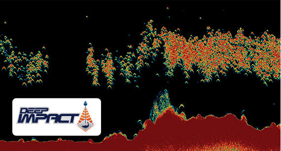
Deep Impact TruEcho CHIRP™
High-powered TruEcho CHIRP™ is available for NavNet TZtouch3 by interfacing the Deep Impact (DI-FFAMP) to the internal Fish Finder. Deep Impact boosts your power to a 2/3 kW CHIRP Fish Finder. High-powered TruEcho CHIRP™ ensures that your echoes come back strong & clear at every depth range, displaying fish targets and bottom structure with amazing clarity.
*Connectable to TZT12F/16F/19F only.
Fish-It & Drift-It
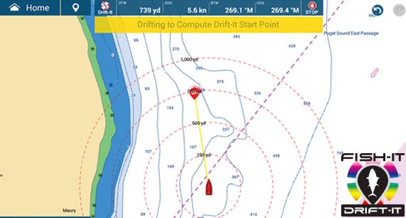
Tap on a fishing location such as a pinnacle, wreck, artificial reef, point, or any place on the screen to activate. Fish-It stays active until you tap the stop sign on the top display.
Once a Fish-It point has been selected, the Drift-It feature can be activated on the data bar. Once activated, Drift-It automatically calculates your drift starting location to allow perfect drift over the Fish-It spot.
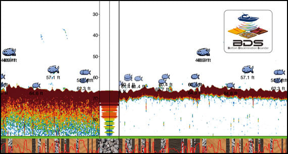
Bottom Discrimination display*
Bottom Discrimination provides detailed information about knowing the make-up of the seabed & categorizing it into four different categories: Rocks, Gravel, Sand, and Mud. The make-up of the seabed can be tremendously helpful information when looking for fishing grounds, as well as for finding favorable anchoring spots.
*Feature works with certain transducers. Check to ensure your transducer is compatible.
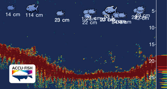
ACCU-FISH™ fish size analyzer*
The ACCU-FISH™ algorithm analyzes echo returns in order to compute individual fish size. The algorithm is capable of calculating fish size ranging from 10 cm up to 199 cm (<4" to <78") long. Fish depth can also be displayed.
*In some instances, fish size indicated on the NavNet TZtouch3 may differ from its actual size. Please carefully read the operator’s manual before utilizing this feature.
Unleash the power of TruEcho CHIRP™ with the DFF3-UHD
The DFF3-UHD High Power TruEcho CHIRP™ Fish Finder for NavNet TZtouch3 delivers the ability to see fish and bottom structure deeper and clearer than ever before.
Furuno’s superior digital signal processing interprets echoes from fish and underwater structures with unparalleled clarity, accuracy, and resolution at unprecedented depths - we’re talking maximum depth scales down to 4,500 meters/15,000 feet!
ADDITIONAL FISH FINDER OPTIONS
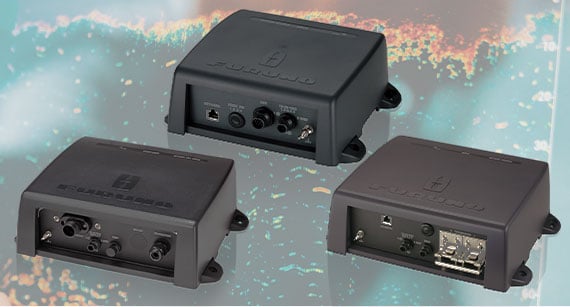
In addition to the built-in Fish Finder, you can also connect the DFF3, BBDS1, or DFF-3D via Ethernet.
More power to see 120˚
PORT-STARBOARD and in 3D
An edge over the competition.
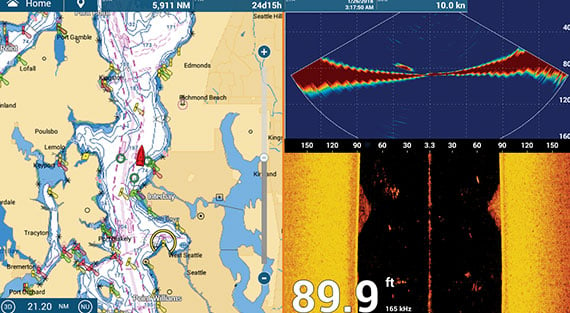
The DFF-3D Multibeam Sonar operates at 165 kHz, giving you fantastic depth penetration while still displaying echoes in high resolution. Compared to a 40˚ ultra-wide transducer, you will see three times the area around your boat, helping you to find fish you might have otherwise missed. Plus, you can see which side of the boat they are on!
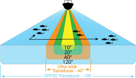
Normal down-sounding Fish Finders have a beam angle of 40˚ or less. But with the DFF-3D Multibeam Sonar, you see 120˚ port-starboard for 200 m (650+ ft). Plus, with the power of the DFF-3D, you can see fish directly below the boat 300 m (nearly 1,000ft). When you match this with the Deep Impact TruEcho CHIRP™, you’ll have the ultimate fishing machine!
EASILY SEE WHERE TO DROP LINES
When you find fish, you can quickly drop a mark on your Chart Plotter for a return drift. Then looking at the DFF-3D’s Cross Section and Side Scan Modes (right side of the screen), you can easily determine which side of the boat the fish are on, how deep they are, and how far out from the boat they are swimming. It’s almost like you have a tracker attached to them!
USE DFF-3D WITH YOUR FISH FINDER
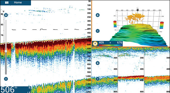
This powerful combination helps you get on the fish like never before. Use your standard Fish Finder on low-frequency to go deep (left side of the screen), and then use the DFF-3D for your high-frequency to see fish in the water column. With the 3D History and Triple Beam Modes, you can easily see which side of the boat the fish are located, so you know where to drop your line.
Furuno has a transducer for every vessel. Click here to learn more about transducers and what makes them tick.
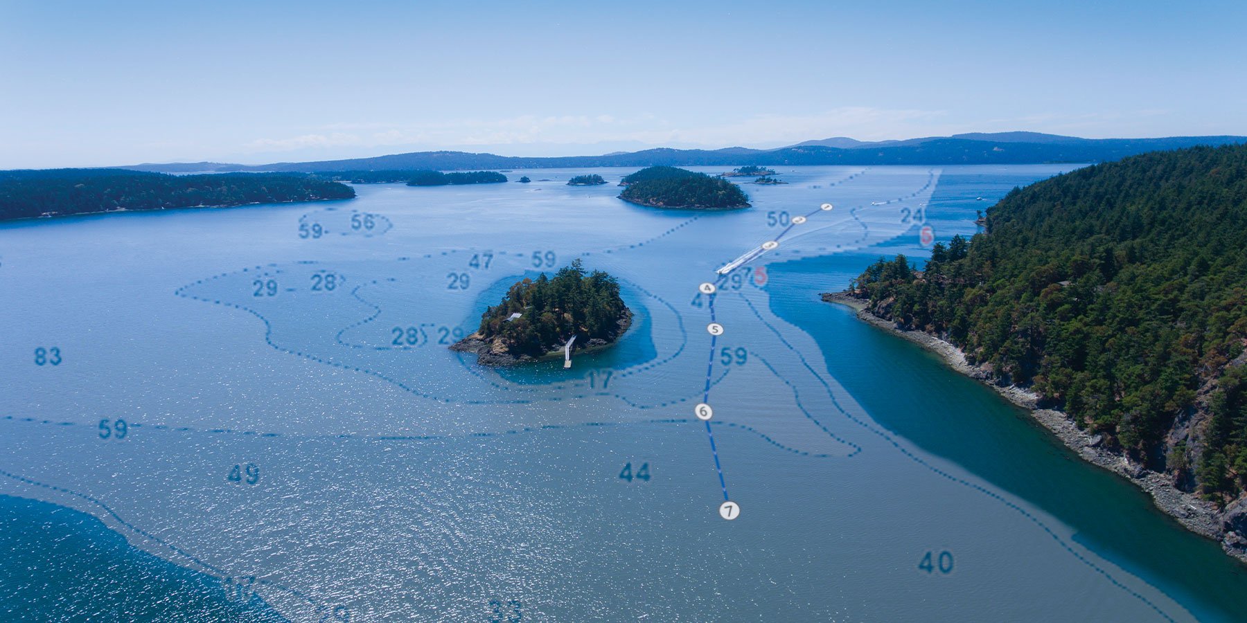
When life throws a CURVE, here's how you stay on course.
Learn about TZtouch3 for Navigation
